高度與等高線 Height & Contour line
教學指引
以下示範為如何以 ARGEO Portable 教授高度與等高線單元
The following demonstration shows the teaching procedures of Height & Contour line by using ARGEO Portable.
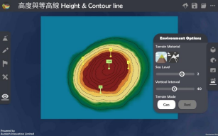
在「預設地形(Preset Terrain)|preset_terrain|」中,選擇「高度與等高線」。
Apply the “Preset terrain
 ” function. Select “Height & Contour line”.
在「環境調整(Environment Options)|environment_options|」中調節「垂直間距(Vertical Interval)」至 40。
Adjust the “Vertical Interval” to 40 on the “Environment Options
 ”.
”.
利用已預設的高程點及其他等高線指示,找出 A 點、B 點和 C 點的高度。
Refer to the information provided on the map. Find the height of point A, B and C.
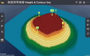
老師可以再塑造更多地形教導學生。
Teachers can create more landforms for teaching.
下載教學資源
教學指引 按此下載
工作紙及答案(中文版) 按此下載
工作紙及答案(英文版) 按此下載